|
Orkney
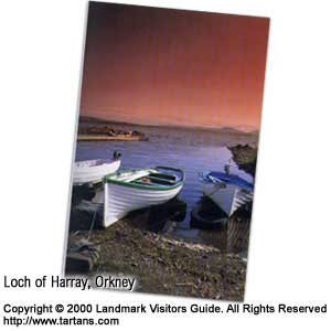
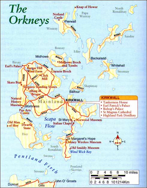
The islands of Orkney, clearly visible from John O'Groats or dunnet Head on the mainland, appear like giant chunks of chocolate topped with green icing as the ferry nears. Further inland are medium-sized, rounded mountains reminding you that this was once, many thousands of years ago, part of the Scottish mainland. From the ferry, with binoculars, grey seals can be spotted basking on coastal rocks while the air is full of sea birds. The Old Man of Hoy, a 450ft (137m) rock stack off the southern island of Hoy, comes into view. Major Towns Stromness The St Ola slips noiselessly past Point of Ness to dock at the North Pier in Stromness and bands of eager back-packers abandon the outer decks to spill onto the dock. The scale of the large ferry transporting around 400 people and 100 cars to the tiny, grey town seems disproportionate. Having been enthralled by the views from Dunnet Head on the mainland, across the Pentland Firth and past the great sandstone pillar of the Old Man of Hoy, the ferry passengers are usually beguiled by the size of Stromness. Grey-lagged cottages line the waterfront with their gable-ends seaward to conserve heat and stave off draughts. For an hour or so the narrow flagstone-paved street, just wide enough for one car, rings with accents from around the world as arrangements are made for accommodation, transport and food. Then it subsides back to a serene harbour community, little changed in a hundred years. Stromness is Orkney's second main town and once a principal sea-fairing outpost supplying ships bound for the Atlantic and North America. Vessels belonging to the Hudson Bay Company regularly stopped here for supplies and to hire local men to work in Nor'Wast up until the early 1900's. Whaling provided another good source of commerce, with ships sailing for Greenland and back, and there was also the herring boom of the late 1800's. The town today remains a fishing port, with a colourful mixture of trawlers and several lobster and crab boats. Stromness Natural History Museum has stood since 1858 exhibiting the highlights of Stromness's history and natural surroundings with presentations on indigenous birds, fossils, shells and butterflies. There are also exhibitions on the Hudson Bay Company, whaling, fishing, and the scuttling of the German fleet at Scapa Flow. Nearby, the Pier Arts Centre on Victoria Street houses contemporary art exhibitions as well as a permanent display of works of the St Ives School. There are other areas worth exploring by foot if you stay in the area and the Tourist Office on the quayside will give details. Do not call there when the ferry has just landed as it gets very busy. There is a very respectable 18-hole golf course at the south end of town with most of the fairways open to the stiff south-west winds. If you follow the beach or cross the hill near the golf course there are good walks past the course and on toward the Point of Ness. Orkney's 'mainland' (as it is referred to) is the largest island on which three-quarters of the 22,000 population live. The archipelago has 70 islands altogether. Known as Orkney and not 'the Orkneys', only 20 of these islands are populated. Kirkwall
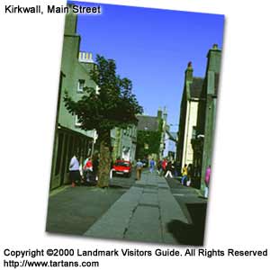
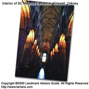
Vikings of the late eighth to thirteenth century played a major role in the islands' development, using their ocean-going sailing ships or long boats to transport men of arms, livestock, goods and emigrants across the North Sea and beyond. The existing Pictish culture was soon absorbed and political control of Orkney and much of the far north and west of Scotland was achieved by the ninth century, bringing advancements in metal-work, farming, shipbuilding and joinery. Kirkwall's centre holds one of the most impressive symbols of the north's Norse past. The rich, red sandstone edifice of the twelfth century St Magnus Cathedral dominates its surroundings and comes as a surprise to many visitors who did not expect its grandeur.
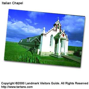
The impressive stature of this building gives a sense of the vast power of the Viking Jarls or earls who commanded these lands. Commenced in 1137 by Earl Rognvald in honour of his uncle, Earl Magnus Eriendson, the story behind his canonisation perhaps owes more to political intrigue than to his religious piety. As part of the Viking territories, the two cousins, Hakon Paulson and Magnus governed the islands. It was the more popular Magnus's refusal to fight over the islands and his turning to prayer in the face of his cousin's treachery and murderous greed that elevated the Earl to the position of a saint. The bones of St Magnus and his nephew, St Rognvald, discovered in 1919, are buried in the north and south choir pillars of the cathedral. The cleft in the skull found in the south arcade correspond to the mortal wound delivered to St Magnus by Hakon's cook, the only man who would consent to do the deed. The Romanesque features of the cathedral in England's north-east, mainly due to the role of Durham, St Magnus Cathedral compensates by its solitary grandeur. The interior appears larger due to the great height of the nave and choir. An interesting interior embellishment is the many seventeenth century grave slabs that line the gallery walls. The bell tower was added to the main twelfth century building in the early fourteenth century. Fortunately, the ravages of the Reformation that destroyed most of the Scottish mainland's religious buildings did little to affect the cathedral. The building is not owned by any one religious body but belongs by Royal Charter of 1486 to the people of Kirkwall. To the west of St Magnus Cathedral on the other side of the street are the ruins of the twelfth century Bishop's Palace. It was originally built in the time of King Haakon Hakonsson of Norway who came here following defeat at the Battle of Largs in 1263 and died that winter from his wounds. The palace fell into ruin in the fourteenth century but was rebuilt by Bishop Reid in the mid-sixteenth century. A more graceful ruin, the Earl's Palace lies, once again, across the road to the south, a tribute to one of Orkney's darker figures, the Earl Patrick Stewart or Black Pate. Opposite the cathedral in Albert Street is Tankerness House, Orkney's main museum. This former sixteenth century merchant's house presents a broad overview of Orkney's past from prehistoric to present times. Many facets of Orcadian life have been brought together including examples of the Orkney straw chair, an intriguing device intended to keep drafts off the occupants by a close-knit straw plaiting forming a large cowl. There are several old houses nearby including the Orkney Library, which is one of the oldest public libraries in Scotland dating back to 1683. Its Orkney Room contains detailed information on the history of the islands. There are some interesting shops in Broad Street and Albert Street, Kirkwall's main shopping parades. There is an Ortak jewellery shop in Albert Street selling beautiful Scottish jewellery. If you wish to see it made, the factory sits just outside town in the Hatston Industrial Estate and welcomes visitors. In Holm Road on the south side of town heading towards the airport is Highland Park Distillery, the most northern Scotch whisky distillers in the country where tours are held and drams are offered. Kirkwall's harbour is still busy but relaxing to stroll around and watch the variety of vessels berthed there. Sheltered between two wide peninsulas, Kirkwall and its harbour were natural sites for early settlement and this area was probably the first to be developed. Formerly the harbour frontage was a line of defence for the small community. The present Shore Street and Harbour Street were then called the Ramparts. You are bound to hear about one of Kirkwall's more unusual traditions on your explorations, the 'Ba Game'. The 'Ba Game' is a tradition played out every Christmas and New Year's Day by the young men of the town. Two teams, the Uppies and the Doonies, originally referring to which part of town the teams came from but now more connected with family or peer group allegiance, struggle to place the ball in the other teams' goal, either the harbour or the corner of Main Street. The game can go on for hours with massive 'scrums' stuck in one of the narrow lanes. A very similar game, even using similar words, is still played at Shrovetide in Ashbourne, Derbyshire. Although the date of the match differs, the playing of football at Shrovetide used to be popular in Britain, but now only Ashbourne and Kirkwall carry on the tradition. To explore the rest of Orkney's mainland there are several options. Below and to the east of Kirkwall are several spurs of land. East Mainland East Mainland encompasses the areas of Holm, pronounced 'Ham', St Andrews and Deerness. On the A960 is Kirkwall's airport, Grimsetter. There are minor roads allowing access to the coast on the St Andrews and Tankerness Peninsula where the remains of World War II gun emplacements can be seen at Rerwick Head. The strategic significance of these islands is borne out by the amount of such sites throughout the islands. On Deerness, recent archaeological excavations have revealed the presence of considerable Pictish and Norse remains especially near Skaill. Further on is a natural chasm where a cave has collapsed leaving an arch that causes an unusual sound. There is a RSPB reserve further north at Mull Head. The East Mainland's roads filter down to the little community of St Mary's. In Graemeshall House on the eastern side of the village is a collection of antiques called the Norwood Collection after its founder, Norris Wood, who has gathered relics of all sorts since he was a teenager. He is now in his 80s. There are five rooms of assorted paraphernalia from around the world and is well worth seeing. The Churchill Barriers are a series of man-made causeways linking the mainland to the smaller islands of Burray and South Ronaldsay. On the west side of these islands is a great, natural deep-water inlet called Scapa Flow. Here the Grand Fleet of the British Navy during World War I gathered, constantly aware of the danger of German U-Boats entering the Sound between the two islands. One did so but decided not to attack. Its periscope was spotted and he was rammed by a British mine-sweeper. Various old ships were sunk between the islands to try to prevent further attacks and some of these can still be seen. At the end of the war, some seventy-four ships from the German Fleet were brought to Scapa Flow following the Armistice. They stayed for several months, then on 21 June 1918, Rear Admiral Ludwig von Reuter gave the signal 'Paragraph Eleven' which was the code to scuttle. Some of his fleet still lie on the bottom of Scapa Flow. Little could Reuter have realised that he had created, some 70 years later, an underwater theme-park for the thousands of divers that come here each year. Fishing boats in the area have found a new lease of life by taking divers out to dive the wrecks of Scapa Flow. The story of Scapa Flow does not end there. During World War II a German U-Boat succeeded in a daring midnight raid in penetrating the British defences and sinking the battleship Royal Oak. One of its torpedo propellers can be seen in Stromness Museum. After this the Churchill Barriers were rapidly constructed to block the eastern entrance of Scapa Flow. The labour problem in building the causeways was solved by using Italian prisoners of war, taking four years to finish the job.
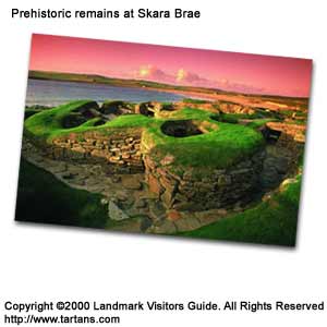
South Ronaldsay The next island is South Ronaldsay. Here, the village of St Margaret's Hope denotes the time in 1290 when seven year-old Margaret, the Maid of Norway, daughter of Alexander III of Scotland, died on her way to marry Prince Edward, later to become Edward II. The hope was that the marriage would unify Scotland and England. The village of st Margaret's Hope is reminiscent in style of Stromness and has the Old Smiddy Museum with artefacts of that trade. There is also the Orkney Wireless Museum at the entrance to the village which houses various communications equipment with special interest in the radar and air defence gear used to protect Scapa Flow. The Creel in St Margaret's Hope is a nice dinner-only restaurant serving delicious seafood. At Wind Wick Bay, grey seal mothers are often seen with their pups. Nearby is the Tomb of the Eagles where an ancient burial cairn was discovered when a farmer saw what looked like a dyke and, taking away a few stones, discovered the burial chamber. In it were some 16,000 bones from around 340 bodies estimated to be around 5,000 years old. A recent study showed that the gene markers from these bones were very similar to Orkney's present native population, showing that the Viking influence is not as marked as many believe and that many Orcadians remain closely related genetically to their most ancient relatives. There is a summertime-only ferry running from Burwick on the south of the island to John o'Groats. West Mainland Returning to the Orkney Mainland, the area to the west of Kirkwall offers some of the most ancient sites of human habitation in Northern Europe. The first is Maes Howe, 10 miles (16km) west of Kirkwall on the A965. From the air, Maes Howe appears like a giant sombrero. The centre lump is a burial cairn, probably the best to be found in Britain. It is reached from the car park at Tormiston Mill by a quarter mile walk following the perimeter of a field. On a well sign-posted right turn found further along the A965 is the Ring of Brogar set on a strip of land between the 36 standing stones set out in a great circle. There were 60 stones when the ring was first created around 1560BC. There is wide speculation as to the purpose of such rings - a landing pad for inter-galactic travellers, goal posts for some ancient football game, to the more sensible idea of a lunar observatory. There is a worn path around the ring of stones with heather in its centre and an outer ditch. Nearby are the Stenness Standing Stones which date from around the third millennium BC. There are only four remaining, the tallest of these standing 16ft (5m). Evidence of cremation and burial has been found around the site. Maes Home Burial Cairn The walls and the roof of the entrance passage are made of huge stone slabs some 18ft (5m) in length and 4ft (1m) wide. The central chamber is similarly formed with a precision that defies the weight of its own structure. During the winter solstice (December 21st), the shortest day of the year, a shaft of sunlight shines directly down the single 30 foot passage, eerily illuminating the interior. The tomb, probably the burial place for important priests or kings of an era around 2,500BC, was broken and entered by Norsemen of the twelfth century and any treasure or artefacts were then removed. In their place they left graffiti, the largest collection of runic characters found in any one place. Their messages, unfortunately, are not always so meritorious. Whilst there is a notation that indicates the tomb's treasure lies buried north-west of the mound, others describe the sexual attributes of certain Norse maidens! Skara Brae Perhaps Orkney's best known treasure is Skara Brae located on the west shores of the mainland overlooking the Bay of Skaill and the Atlantic Ocean. Easily the best preserved of its kind in Europe, this late Stone Age village dates back 5,000 years. Ironically it was only inhabited for around 600 years before a severe sandstorm sealed it away. In 1850 a similar storm revealed this time capsule to the world. In all there are six houses and a workshop situated around an adjoining passageway. Much of what we see now, although incredibly intact, excludes the wood and animal hide furnishings that must have accompanied the stone dressers, beds and cupboards that remain. Although the Bay of Skaill was smaller and further away from the site in their time, the inhabitants of Skara Brae made use of the drift wood and whale carcasses that were blown ashore to augment their furniture.
Five miles (8km) further on and following a road down to the beach is Gurness, the best preserved broch or village in Orkney dating from around the first century BC. The site was probably occupied well into Viking times where the defensive tower surrounded by the domestic dwellings was probably frequently used. Looking back to the mainland from Gurness you cannot fail to notice the huge aerogenerator of windmills at Burger Hill Wind Farm. The experimental scheme chose this area due to the high average wind speeds that prevail. There is a small, explanatory Visitor Centre and the RSPB Birsay Moors Reserve nearby. Around the north coast of the Mainland to its western tip is the parish of Birsay, with its imposing sixteenth century ruin, the Earl's Palace. Birsay was once an important Viking settlement until the cathedral was constructed in Kirkwall and the Viking seat of power was transferred there. Before the Vikings, there was a Pictish and early Christian community settled on the Brough of Birsay, the small island reached by stepping stones at low tide and only passable for around 2 hours each day. There is much evidence of the buildings that stood here, now mere outlines of stone in the rich meadow that surrounds them. Hoy The island of Hoy to the south of Mainland is Orkney's second largest island and quite different in topography, with elevations such as Ward Hill rising to 1,577ft (481m), Cuilags at 1,420ft (433m) and Knap of Trowieglen at 1,310ft (400m). This makes for good hill walking country although more serious mountaineers make for the Old Man of Hoy to scale its vertical walls. The island is reached by either of the two ferry services, the first from Stromness Harbour to the village of Hoy is passenger and summer only, while the roll-on roll-off service from Houton on south-west Mainland to Lyness on the east side of Hoy runs all year. Between Hoy, the south coast of Mainland and South Ronaldsay lies Scapa Flow, the scene of so much naval activity during both World Wars, so that Hoy and its east coast village of Lyness were much involved. In fact Lyness was the main naval base with over 60,000 personnel living in mainly makeshift wooden huts. It was here that the German Fleet of World War I, what was left of it, was beached and stripped. The Lyness Naval Base was finally closed in 1959 and now an Interpretation Centre remains to try and convey the important role this area played in both World Wars. The area to the south of Lyness is more flat and fertile with the road leading on to South Walls. On the island of South Walls you may be surprised to see a person running around fields flapping his arms. Here they employ a human scarecrow to keep Barnacle Geese off the crops in late summer and autumn; the system seems to work quite well. The north of Hoy is more suitable for sight-seeing with the route over to Rackwick being the best option. The Dwarfie Stane, a cramped rock tomb thought to date from around 3000BC is ited just south-east of the road. There is a good path but it deteriorates, so wear proper boots or water- proofs. At the end of the road is a view of dramatic coastal cliffs and a wide sand and boulder beach. It is a sheltered area on most days. From here there are good walks inland by Ward Hill or following the coastal footpath to the Old Man of Hoy which takes around 3 hours there and back. It is possible to carry on to the awesome 1,140ft (348m) vertical cliffs at St John's Head. This takes considerably longer, and bear in mind that you get an excellent view of the cliffs and the stack from the Stromness to Scrabster ferry. The Northern Isles Lying north-west of Kirkwall and the Mainland are a spattering of lovely islands collectively called the Northern Isles, a more elemental and quite addictive side to Orkney. Almost all their names end in -ay which was Norse for 'island'. Shapinsay Shapinsay is closer to Kirkwall and the most developed, a 25-minute crossing on the roll-on-roll-off ferry. The island's system of runrig farming was 'improved' in the 1850s by the Balfour family, originally from Fife, who built Balfour Castle around an existing house and occupied it until 1961. Now it is owned by the Zawadzki family who offer tours of their home and gardens followed by a traditional Orkney farmhouse tea served in the servant's hall. Rousay The island of Rousay is just 1 mile north of the Mainland and is reached by the short ferry crossing from Tingwall. It is a perfect escape for those interested in archaeology, bird-watching or fishing. A single circular route runs round the island and passes near most of the prehistoric, Pictish, Viking, ornithological and good fishing sites. The best archaeological sites are found on the south-west shores of the island. The most impressive is about 5 miles (8km) west of the ferry terminal, Midhowe, a communal burial cairn similar in age to Maes Howe and referred to as the 'slip of death'. Nearby Midhowe Broch is the remains of a small, fortified Iron Age village or large family dwelling. Nearer the ferry terminal is Taversoe Tuick, a two-storey tomb which is quite unusual although another exists like it on Eday. Wyre The low-lying islands of Wyre which contain the Cubbie Roo's Castle, a twelfth century stone building and Egilsay, best known for its St Magnus' Cenotaph and church, can be visited by asking the ferry staff to drop you there. Eday If you are waiting in Orkney's main airport at Grimsetter and hear announcements for flights leaving for London Airport, in this case, is on the island of Eday set in the middle of the North Isles and not at Heathrow. The island's central position has made it an exporter of peat to other less-endowed islands, and most of the hilly interior is given over to this occupation. The ferry lands at Backaland on the south-east side but most of the interest is further north. It is around a 5 mile (8km) drive on the Eday's main road to the Stone of Setter, a single, lofty, Pictish monolith. The nearby chambered cairn of Vinquoy is the best of many found on this island. It is similar to Maes Howe and Midhowe with its large stone block walls and four chambers set into them. Westray Westray is a spindly long island to the north-west of Eday and the largest of the North Isles, with Peirowall being its main community. It is a surprisingly prosperous place with cattle farming and fishing being its main occupations, although it is noted also for its knitwear. Notland Castle, built in 1560, is about half a mile walk from the village, a set of square sections forming a Z-plan that is adorned with some seventy gun loops. Noup Head Cliffs are on the north-west side of the island, a haven for bird-watching that rates as one of the most important breeding sites for sea-birds in Europe. The Pierowall Hotel is the best bet for lunch. Papa Westray Papa Westray or Papey has an international reputation as having the shortest scheduled airline flight in the world lasting between one and two minutes depending on the wind. This takes place between Westray and the beach of Papa Westray. The north part of this island around North Hill is uninhabited apart from thousands of Arctic Terns and Scuas. They will buzz you if you wander too close to their nesting sites and deliver a nasty peck unless you wear some head protection. Underfoot is some interesting vegetation such as Spotted Orchids, Primrose and Dog Violet. The Knap of Howar near the airfield is very similar to Skara Brae on Mainland. Here a sand-storm covered a farm dwelling of 3500BC which was subsequently uncovered to reveal what is claimed to be the oldest standing house in Europe. Sanday If you land on the island of Sanday on a warm summer's day you may think the ferry was blown off course and landed in the Caribbean. Sanday, as its name implies, is surrounded by fine, powdery beaches and is the flattest of the North Isles with the only noticeable rise being the aptly named 'Wart'. Its position on the eastern edge of Orkney's outlying islands has made it a hazard to shipping and scores of ships have been cast to a watery grave off its eastern-most point where a lighthouse now stands, constructed in 1807. This is an area worth visiting, so to reach it take the route out of Kettletoft and turn right along the Lady Peninsula. En-route there is a worthwhile stop at the Knitters Wool Hall in Lady Village. On El Ness there is perhaps the best of Sandy's many prehistoric sites, Quoyness Chambered Cairns, again similar to Maes Howe but smaller. There are other Neolithic burial mounds throughout this island. Stronsay Stronsay is the most eastern island of the archipelago with several lovely, sandy beaches and is also well known for its rich, arable land. Stronsay was a point of convergence for the herring industry through the nineteenth century but was more famed for the 'Great Kelp Boom' of the early nineteenth century, when seaweed was harvested and sold as potash and soda. Now it has settled back to doing what it does best, farming. The village at Whitehall is little more than two rows of cottages with a hotel and a pub but the main attraction of this area is exploring the coast. Bird-watching is always available throughout the Northern Isles so it is useful to bring a pair of compact binoculars. The Vat o'Kirbister on the island's south-east shore is a dramatic opening or 'gloup' spanned by the finest natural arch in Orkney. It gets its name from the peculiar gulping sound made as the sea swells through it. North Ronaldsay
This remote island, some 30 miles (48km) north of Kirkwall, has a very unique native breed of sheep that feed mostly on seaweed. This mottled breed has supposedly been on North Ronaldsay since before the Viking period. A dry-stone dyke has stood for over 100 years, almost surrounding the island, to keep the sheep off the arable land. Kelp has also been important as part of the island's economy as an exportable commodity, but now it is farming that sustains North Ronaldsay's ageing population. With a lack of other distractions, it is the wildlife, migratory birds and seals that attract attention here. The best seasons for bird-watching are spring and autumn but there is some activity through most of the year. There is the North Ronaldsay Bird Observatory on Twingness
Croft on the south-west side of the island, a wind and solar powered cottage that
offers accommodation and board along with insider information on how to make the
most of 'twiching'. |
Thursday, December 26th, 2019
Attention visitors: Tartans.com is back. Please note that this is a snapshot of the site as it existed nearly 20 years ago and you may encounter broken links; we are still combing through the site and correcting those as we find them. Please also note that some sections are currently not functional, primarily the discussion forums/clan chat boards.
|
** HOME - First Time Visitors - Glossary - - Contact Us ** Awards | Bibliography | Clan Calendar | Clan Chat | Clan Finder | History | Famous Scots | Genealogy | Great Hall of the Clans | Links | News and Features | Scots on the Net | Search | Site Map The Gathering of the Clans
Copyright 1995- Tartans.com - All Rights Reserved. |