|
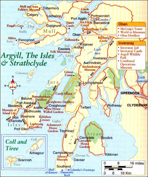
The Kintyre Peninsula The mid-Argyll market town of Lochgilphead marks the start of a tour of the Kintyre Peninsula. This is a hub for the smaller communities nearby, with provisions such as the only bank and supermarket for some distance.
The A83 continues along the mouth of Loch Fyne to Tarbert before crossing to the western side of Kintyre. To the west is the more diminutive lump of Knapdale, a quiet, less trampled corner. There is a circular route worth taking, the B8024. It is a delicate environment here with admirable views over to Jura and Islay, and its main focus is usually Loch Sween with its Castle Sween to the north. The fishing village of Tarbert appears idyllic as the road descends into town. This is the terminal end of the deep West Loch Tarbert and each morning small fishing trawlers head out to the seas surrounding the Inner Hebrides. If not for the thin stretch of land inhabited by Tarbert, Kintyre would be an island. There is a rubble-reduced castle above the town called Bruce's Castle, but the best way to employ your time here is to walk out by the loch and enjoy the peace. The Columba Hotel is one of the cosiest with mesmerising views over the loch. This serves also some of the best bar meals in town. Just south of Tarbert on the A83 is the ferry terminal of Kennacraig which serves the Inner Hebridean islands of Islay, pronounced 'Isla', and Jura. It is a two hour crossing to Port Ellen on Islay, some 25 miles by 20 miles (40km by 32km) and the most southern of the Inner Hebrides. Islay and Jura
For today's visitors the southern shores of the island around Port Ellen could offer all they might need with three world famous whisky distillers and a unique 18 hole golf course. It is possible to fly to Islay from Campbeltown on Kintyre or from Glasgow Airport with the airport being minutes away from the Machrie Hotel and Golf Course. Islay Whiskies are in the premier division of Scotland's malt industries. The strong, peaty, smoky flavour of Islay whisky comes about with the peat burning process and the sea air in which they are stored giving them a tinge of iodine. Bowmore, Lagavulin, Laphroig and Bunnahabhainn are produced here, and each distillery offers tours and samples of their produce. There are a total of eight distilleries on the island. Near Port Ellen is the island's most important artifact, the Kildalton Cross; made more than 1,200 years ago, it is inscribed with early Christian symbols and is unlike the cross found in Iona's cathedral. Bowmore, further north on the A846, was the capital of the island. It is another distillery town with its whisky production established in 1779. Overlooking Loch Indaal is a 200 year-old round church, which was designed to do away with corners in which evil spirits could hide. Around the bay is Port Charlotte with is Museum of Islay Life set in a converted church. There are examples of craft working tools, a maritime section and information of the standing stones and burial cairns of the area. Islay is popular with bird-watchers, especially around the sandy bay at Craigens. Fishing for trout and salmon is excellent in the many rivers and lochs and there is easy accessibility to sea angling. Islay's importance as a medieval centre was focused around Finlaggan Castle, a seat of the MacDonalds and now a mossy ruin just off the road before Port Askaig. From Port Askaig there is a short ferry hop to the neighbouring island of Jura. Jura is not developed with only one 24 mile (39km) long, single track road and very few people. The majority of the island is only accessible by foot. This may be why Eric Blair (otherwise known as George Orwell) chose it as an escape to write his novel 1984. Towards the headland is the Gulf of Corryvreckan where an infamous whirlpool occurs at certain tides capable of swallowing whole boats. Deer are abundant around the Paps of Jura, two breast shaped rises that dominate the skyline. Bird watching and gentler walks are the main activities on Jura. There is the Craighouse Distillery producing Jura malt whisky in the island's main centre of Craighouse where there is also a hotel and general store-come-post office, a tea-room and hairdresser. Gigha Returning to the mainland there is the ferry terminal for Gigha at Tayinloan. Washed by the Gulf Stream, fertile Gigha is the tiny island between Kintyre and Islay best known for its cheese. Arminish is the main centre. The island has changed hands several times since being sold by its original laird. One buyer was Sir James Horlick of hot-drinks fame who established the marvellous garden at Achamore House. Taking the roller-coaster road, the B8001 brings you to the desolate little landing for the Claonaig to Lochranza ferry on the island of Arran. If there is nobody else there, wait around and eventually more cars or the ferry will arrive. There is a choice of traversing the Kintyre peninsula, either by the main A83 which is fast and relatively scenic or by the tortuous B842 following the east coast, much demanding and more rewarding with leafy twists and wide views over to the mountainous side of Arran. You eventually reach the village of Carradale which has a delightful little harbour and a testing 9 hole golf course. There are walks through Carradale Forest and out to Carradale Point. Carradale Hotel with the golf course adjacent, offers golf breaks where you stay at the hotel and play free golf, as well as a leisure club, two squash courts, sauna and solarium with occasional, large-screen film shows. Carradale House Gardens are walled gardens dating from about 1870. Campbeltown and the south Campbeltown is the central municipality for the area, a former herring fishing port and once hub of assiduous whisky production, so recalling the song 'O'Campbeltown Loch, I wish ye were whisky'. Only two whisky distilleries are now left in the area, but at one time there were a total of thirty-four such businesses in and around town. A fourteenth century cross graces the only round-about in town in front of the harbour and Tourist Information Office. There is a small museum in the local library with some local exhibits. Campbeltown Creamery on Witchburn Road produces and sells 'Truckle' which is a mature cheddar wrapped in wax and worth taking away. Perhaps the most popular attraction in this area is a cave on Davaar Island which lies off Kildalloig Point east of town. Before heading out check with the tourist office the times of the safe walking tide. A single spit connects the island with the mainland and here, in a cave, a painting appeared in the late 1800s of the crucifixion, lit only by a shaft of light from above. It was not until 1934 that the artist owned up; a local man called Archibald MacKinnon. Continuing south on the B842 leads through the Mull of Kintyre, another area made famous in song when Paul McCartney of The Beatles retreated here. The coastal town of Southend is set south of some of Kintyre's best scenery but the village does little to augment the natural scene. Dunaverty Rock was the site for Dunaverty Castle, now no longer in existence.Back to the mainland
The return drive from Mull of Kintyre and Campbeltown along the A83 to Inverary or Oban can seem tedious as you are forced to back-track along the A83. Alternatives back to Scotland's central belt exist, for example by taking the minor B842 from Campbeltown to Claonaig, a windy and lumpy road but with fine views of the west side of the island of Arran. During the summer months a ferry crosses from Claonaig
to Lochranza on the north tip of Arran, from where you can drive down to Brodick
on the island's east side and take another short ferry crossing to Ardrossan on the
mainland, some 30 miles (48km) south-west of Glasgow. With the cost of the ferries,
this method is rather more expensive but it avoids a long drive and gives you the
chance to see the beautiful island of Arran. |
Thursday, December 26th, 2019
Attention visitors: Tartans.com is back. Please note that this is a snapshot of the site as it existed nearly 20 years ago and you may encounter broken links; we are still combing through the site and correcting those as we find them. Please also note that some sections are currently not functional, primarily the discussion forums/clan chat boards.
|
** HOME - First Time Visitors - Glossary - - Contact Us ** Awards | Bibliography | Clan Calendar | Clan Chat | Clan Finder | History | Famous Scots | Genealogy | Great Hall of the Clans | Links | News and Features | Scots on the Net | Search | Site Map The Gathering of the Clans
Copyright 1995- Tartans.com - All Rights Reserved. |