|
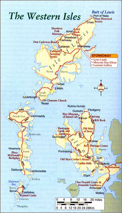
The Western Isles The real beauty of these wild outer-lands is in their natural form. Man's interaction has done little to disturb this and it is, no doubt, the remoteness from modern civilisation that has helped to preserve some of the most essential elements of the place. If you are walking or even driving, the grey skies and barren landscapes still enter your sight and soul. Some may find this disconcerting but others relish it and most feel curiously uplifted, having visited such a wild and forbidding place.
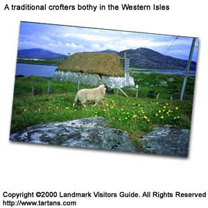
In essence, the Isles are pure place with little evidence, apart from Stornoway, of modern pressures to spoil it. Urban congestion, if you could call it that, only takes place in Stornoway on a Saturday night and noise pollution consists of the howl of the wind. The scenery throughout this island string is simple, essentially sea, sky and low-lying, bare-boned rocks with ample scattering of fine, sandy beaches. Stornaway Stornaway is the main town on the east coast of Lewis and the centre of Hebridean life with some 8,000 of the Western Isles population living in and around the town. Still a fishing centre whose heart is its harbour, that industry now exists as a mere echo of the activity that took place here a hundred years ago. A thousand fishing boats and coastal steamers used to fill Stornoway harbour throughout the nineteenth century, landing their catch and preparing to return to the bountiful Atlantic. Following World War I, Lord Leverhulme of the Lever Brother's empire decided to develop some of the facilities on the islands with the hope of making them the capital of a huge fishing industry. He actually bought the island of Lewis, but a recession and collapse in the herring market put an abrupt end to his plans. The regular ferry from Ullapool causes a stir around Stornoway with the arrival of tourists as well as cargoes of mainland wool for Harris Tweed weavers, timber for an almost tree-less land and various manufactured goods. The town of Stornoway can be rather grey and unappealing if the weather is similar but on a warm summer's day it has a pleasant mainland market-town air, a fine place to sit and watch island life go by. There are plenty of amenities such as hotels, bars or grocers but bear in mind that everything including filling stations close on Sunday to observe the Sabbath. Hotel restaurants are kept open for meals but this is about all. Some B&B landlady's prefer you to book ahead on a Saturday for a Sunday stay. They even padlock the swings in children's parks. The same exists throughout Lewis, Harris and North Uist, the domain of the Free Presbyterian Church, while the predominantly Catholic islands of South Uist and Barra are more moderate regarding opening times. The town is crowned by Lews Castle which is surrounded by the pleasant, wooded grounds of Ladylever Park with advantageous views over the harbour. Next to the park is an 18 hole golf course and the town is a good sea-angling centre. Just off the main square in the town hall there is an art gallery, "An Lanntair', which displays local and national exhibitions and hosts various musical events. The Museum "Nan Eilean" is in Francis Street. It is worth seeking out a bilingual map such as the Western Isles Leisure Map from one of the outlets in Stornoway before you depart, as all the road signs are in Gaelic. The rest of the island Following the A857 out of town and travelling north west, the interior of Lewis looks bare, a peat moor where the only sign of human activity is in the dark, loamy channels cut everywhere to extract peat fuel, the islands' main source of heat. If it is May or June the men will be cutting peat which costs no more than the labour of cutting, stacking it and later in the summer, collecting it. The A857 continues up the north-west coast to the Butt of Lewis, a rocky headland some 30 miles (48km) from Stornoway, worth the trip to see thousands of seabirds that congregate around the lighthouse and cliffs. The village of Ness and its surrounding area are surprisingly well populated and the Harbour View Tea Room is worth a re-fuelling stop. Following the road south again leads on to the A858 and the small community of Arnol where the Arnol Black House Museum shows the lifestyle of crofters not so long ago. This house was built in the 1870s and inhabited until the mid 60s - a fairly chilling thought if you are used to all the comforts of a modern home. There was no chimney and so the interior rafters and much else caught the soot from the fire. These long dwellings were common throughout the Hebrides, built without mortar or bricks and usually thatched but without eaves. At Bragar, the next group of houses on the main road, stands a massive whalebone archway with the harpoon used to kill the poor beast hanging from its centre. From the Butt of Lewis these islands, only twelve of them populated, run along a 130 mile (209km) vertebral column lying 30 to 50 miles (48 to 80km) off the Scottish mainland. The northern-most land-masses of Lewis and Harris are joined by a narrow isthmus although, despite their close proximity, each has its own unique topography and character. Lewis is largely rolling moorland with low-lying hills, hundreds of sparkling little lochans and a rugged coastline, while Harris is more mountainous. Shawbost is the next community and has a small museum which illustrates the old way of life for islanders. This was brought together by school children of the area some years ago and a few of the items are the worse for wear. Carloway, further down the A850, is another taste of life before the twentieth century reached Lewis. Carloway Broch, found on a minor turning a mile or so beyond the village and a slight hike over a track, is a 2,000-year-old, circular, drystone, fortified tower and probably one of the best preserved brochs of its kind in Scotland. The sea ward wall stands around 30ft (9m) high. There are many brochs along Scotland's coasts but, apart from Mousa Broch in Shetland, few are in such good order. These were probably built to protect natives from sea-borne raiders, possibly Roman slave-traders. Located close to A858 beyond the village of Callanish along the B8012 is the 5,000-year-old standing stones of Callanish, a circle and avenue of 71 megaliths almost as famous as Stonehenge in England. Its cruciform shape was probably formed over many centuries from 3000BC to 1500BC. Nineteen monoliths lead north from a circle with more fanning east and west. The fact that the avenue of stones to the north completes a Celtic cross is rather baffling as it was constructed at least 1,500 years before Christ. Harris To drive to North Harris from Callanish is a distance of around 50 miles (80km) as you have to back-track to Stornoway, then follow the A859 south. This leads through the area known as the 'Lochs' due to the multitude of small lochans and deep, penetrating sea lochs. The bare peaks of North Harris appear, a stark contrast to moors and bogs of its larger northern neighbour. The highest peak is An Clisham at 2,621ft (799m), clearly seen from the road. The most elevated areas are found on the east side of Harris with more fertile land on the west. These rocks were old, long before the glaciers of the Ice Age scraped them clean of soil, a part of a North Atlantic that was once part of Greenland until the Atlantic drove in between them. The mountains of Harris trap the township of Tarbert in its narrow isthmus reached by descending down into this ferry port. There are many good walks around this area, details of which are provided by the tourist office in Tarbert. Here you will also find out where to see the world famous Harris Tweed being woven. Harris TweedThe nineteenth century brought the sporting gentry to the Hebrides and they adopted the local, hand woven tweed originally made by the women of the islands to clothe their families. The success of the cloth is borne out with nearly every croft having its weaving shed.
The colours of the Hebridean landscape are said to be woven into the tweed. To see the techniques used in their original form a good stop is Clo Mor in the village of Likisto, some 4 miles (6km) south of Tarbert on South Harris following the A859 then branching left at the sign-post to the village. To the east of Tarbert is a new 'fixed link' or bridge to the island of Scalpay. This is the first in a series of links to connect some of the Western Isles less accessible areas. There are causeways planned soon for Eriskay and Bernary. South Harris On South Harris, the single-track road winds over to the west coast of the island and offers glimpses of the superb stretches of sparkling beaches of which the Western Isles are famous. Leverburgh is past on the south-west corner where Lord Leverhulme turned his attention after the failure of his enterprise in Stornoway. He spent a fortune building new harbours and buildings, but died soon afterwards. A passenger ferry crosses from here to North Uist and Berneray. The island of Berneray lies off the north coast of North Uist, a favourite destination of Prince Charles. It is the only populated island in the Sound of Harris. Continuing east from Leverburgh you enter Rodel on the southern tip of Harris. St Clements Church in Rodel is one of the finest in the west of Scotland and contains the magnificent sculptured tomb of Alisdair Crotach Macleod, a chief of the clan and the eighth chief of Dunvegan. North Uist The Sound of Harris separates Harris from North Uist to the south, which is reached either by the passenger ferry at Leverburgh or by car ferry from Tarbert or Uig on the Isle of Skye, both of which land at Lochmaddy.
Lochmaddy is a pleasant little town, the main centre for North Uist and a good place to establish a base if you wish to tour this area. There are banking, provisions and accommodation facilities. There is a useful circular route following the A867 and it is advisable to explore the side roads that lead down to trout filled lochans mainly on the rolling east side and broad silver beaches found on the west of the island. There is also agreeable farming country on the west but it is the great expanses of white sand beaches that are the islands' best feature. The remote island of St Kilda lies 41 miles (66km) WNW of Grimish Point which is on the north-west corner of North Uist and the island's nearest substantial landfall. Benbecula North Uist connects by a long causeway and bridge with Benbecula via Griomasaigh or Grimsay. Benbecula is where Bonnie Prince Charlie and Flora MacDonald met and then departed 'over the sea to Sky." It is a rather water-sodden, spongy spot apart from its west coast which holds a fertile strip and the ubiquitous west coast beaches. There is an airport and army base on the north-west corner which swells the population and economy significantly, but recent government cut-backs have threatened this. The main road cuts straight through Benbecula covering its 4 mile (6km) length, then joins another causeway to the island of South Uist. Both the Uists as well as many spots on Benbecula are ideal angling terrain with hundreds of erratically shaped lochans. Sea trout, brown trout and salmon can be caught. Fishing is particularly popular on the machar lochs of South Uist for beautiful wild brown trout and in the shallow sea for salmon, sea trout and mackerel. A variety of shellfish are collected and eaten by the locals including cockles that can be gathered when the tide is out on either side of the causeway. South Uist Your entry into the long island of South Uist is marked, about 5 miles (8km) after the causeway, by a 125ft (38m) Statue of Our Lady of the Isles, perhaps to remind visitors that they have left the land of the 'Wee Free' Kirk and are now on Catholic soil. The A865 is the back-bone communication route through South Uist travelling around 20 miles (32km) from the north to south. Off this there are numerous side-roads leading west to the most wonderful stretches of beach. The village of Howmore is worth stopping at, very pretty in itself, and offering a good trek over to a breathtaking part of the western coast. The next turning after Howmore leads to a minor coastal route but it is easy to lose your way. Close inspection of a good map is recommended. A stone cairn marks the birthplace of Flora MacDonald in 1722 just off the main road at Milton. The main base for a stay on this island might be Lochboisdale but, in spite of its facilities such as a bank, shop and harbour, it is not an inviting place. Better still to seek out B&B in one of the cottages around the south end or the hotel at Daliburgh, although pre-booking is always advised in the summer months. Eriskay Off the south end of South Uist you can see the island of Eriskay, where the SS Politician went down in 1941 with her cargo of 24,000 cases of whisky bound for Jamaica from Liverpool. This inspired Compton Mackenzie to write his novel Whisky Galore in which the islanders made brave attempts to 'rescue' the cargo, much as happened in reality. A car ferry runs from Ludag on South Uist to the island of Eriskay, although it is not really necessary to have a vehicle on this tiny island as most of it can be better appreciated on foot. This was the first landing place of Bonnie Prince Charlie on Scottish soil, on 23 July 1745. Barra and Vatersey form the southern tip of the Hebridean Island chain. Again, a single track road provides the main link for the tiny island community of Barra although the airport is situated on a spur to the north of the island. Here the daily Loganair service from Glasgow, Benbecula and Stornoway lands on a long strip of white shell sand, timed to catch low tide. Near here at Eoligarry is the arrival and departure point for the passenger ferry to South Uist. Barra The approach by ferry from Oban, Mallaig or Lochboisdale to Barra is quite delightful, with the striking Kisimul Castle standing out on an islet in the Sound of Vatersay. Its main tower dates from around 1120 and is surrounded by water. The castle was completely ruined by fire in the late eighteenth century and remained so until the forty-fifth chief of the MacNeil clan, an architect, returned in the 1960s from his adopted home in America and restored it to its present admirable condition. Castlebay, Barra's main town, stands out on the rocky eastern coast, a gem of a little port with well-ordered cottages and shops. Above is the rise of 1,260ft (384m) of Heavel, the highest in Barra and upon its slopes stands the statue of the Blessed Virgin and Child. Barra is an ideal escape for walkers who can circumnavigate the island in a day. Thousands of species of wild flower can be found and Barra is carpeted with primroses in springtime. Halaman Bay on the west coast is one of Barra's most bountiful. The popular Gaelic festival 'Feis Barraigh' is held on the island every year in the first fortnight in July. The nearby island of Vatersay can now be reached by a causeway from Barra. Again, it offers lovely beaches and invigorating coastal walks. Mingulay A string of tiny flatter islets form the tails of the Outer Hebrides. The island of Mingulay at the southern end of the Western Isles is like a scene from Robinson Crusoe. It is often referred to as Bird Island as it was evacuated at the turn of the twentieth century and given over to the populations of seabirds that inhabit the cliffs. When there was a community here they made a harvest of the birds, climbing up from boats onto the treacherously sheer walls to catch them on their nests. One hundred years ago there were 150 people living here. The only substantial house left standing is the priest's house, but this was never really occupied as around the same time that it was completed in 1908 the people decided to leave the island. Tiree, with beaches facing every direction, is a haven
for wind surfers. |
Thursday, December 26th, 2019
Attention visitors: Tartans.com is back. Please note that this is a snapshot of the site as it existed nearly 20 years ago and you may encounter broken links; we are still combing through the site and correcting those as we find them. Please also note that some sections are currently not functional, primarily the discussion forums/clan chat boards.
|
** HOME - First Time Visitors - Glossary - - Contact Us ** Awards | Bibliography | Clan Calendar | Clan Chat | Clan Finder | History | Famous Scots | Genealogy | Great Hall of the Clans | Links | News and Features | Scots on the Net | Search | Site Map The Gathering of the Clans
Copyright 1995- Tartans.com - All Rights Reserved. |